-
-
Access Free Student Software
Ansys empowers the next generation of engineers
Students get free access to world-class simulation software.
-
Connect with Ansys Now!
Design your future
Connect with Ansys to explore how simulation can power your next breakthrough.
Countries & Regions
Free Trials
Products & Services
Learn
About
Back
Products & Services
Back
Learn
Ansys empowers the next generation of engineers
Students get free access to world-class simulation software.
Back
About
Design your future
Connect with Ansys to explore how simulation can power your next breakthrough.
Free Trials
You’re standing in an open field. Once full of crops as far as the eye can see, now there is only the golden remains of a completed harvest. However, your work is not done.
It’s time to plan for the next harvest, which will involve determining the health of your soil to ensure that you can get the best possible crop yield next year. One aspect of this process is analyzing crop residue to maintain a careful balance. Too much crop residue can harbor pests, while too little can lead to erosion.
Crop residue measurements also reveal other key information, such as overall crop health, appropriate tillage intensity, carbon sequestration potential, and the potential for agricultural land use and climate science initiatives.
You can perform this crop residue assessment manually by walking around and surveying the soil yourself, but that is incredibly time-consuming. Another option is to survey the land using a drone or plane, but this method can be prohibitively expensive.
Today, there is another choice. For nearly a decade, the University of Toronto Aerospace Team (UTAT) Space Systems student group, an Ansys Student Team Partner, has been designing, developing, and launching small, cost-effective CubeSats — small, standardized satellites — for Earth observation and sustainability. The latest from the group is their Field Imaging Nanosatellite for Crop residue Hyperspectral mapping (FINCH) project, which is expected to launch in the next few years.
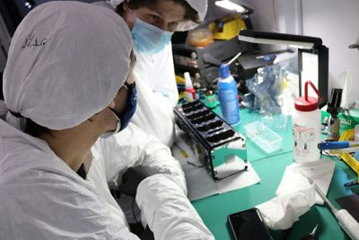
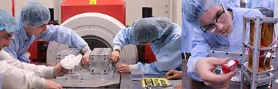
The UTAT team developing a satellite.
FINCH can perform crop residue mapping from low Earth orbit, and it is “the best solution given the price points for the alternatives,” says Iliya Shofman, optics lead for the Space Systems division.
Ksenya Narkevich, current Director of Space Systems and former Opto-mechanical Design Lead, says that FINCH enables agriculture industry professionals to generate important soil information remotely. Also, UTAT Space Systems is actively collaborating with Agriculture and Agri-Food Canada (AAFC) on this project, widening the usability of its work.
This is only one aspect of the amazing benefits and work students are undertaking in the Space Systems division.
The Boundary-pushing Work at UTAT Space Systems
Innovative ideas begin with innovative teams. In this area, the Space Systems division thrives. As a no-barrier team, UTAT Space Systems comprises students from across all engineering disciplines, as well as those from economics, political science, geophysics, and business. The team relies on this expansive skill set to succeed, with every member playing an important role in the team’s overall success.
The Space Systems division also prioritizes enabling the wider community to use its work, which is all open-source, except for work that requires non-disclosure agreements.
Relying on these principles has yielded many successes. For example, their previous project, (Ultra) High Frequency Educational Radio Comms On a Nanoscale (HERON), was the first-ever fully student-funded, student-built CubeSat in Canada.
The team’s current satellite, FINCH, uses short-wave infrared (SWIR) range to produce important data, such as the crop residue data mentioned earlier. The novel FINCH EYE hyperspectral camera payload, which was created via a multidisciplinary research and development effort, stands out by enabling scientifically valuable imaging capabilities with reduced costs compared to similar technologies.
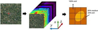
Images depicting how the data generated by FINCH EYE can be used for taking crop residue measurements. The ground target site (left) is imaged by FINCH EYE to generate a hyperspectral data cube (middle). Spectral Unmixing Analysis (SMA) is performed to estimate fractional abundance of crop residue (right).
FINCH relies on a process called spectral unmixing, which, in short, determines the percentage of each material in a ground sample. In FINCH’s case, this technology is used to find the fractional abundance of green vegetation (GV), crop residue and nonphotosynthetic vegetation (NPV), and soil (which has a mixed composition).
The UTAT Space Systems team has published multiple conference papers on FINCH, covering topics such as the mission architecture and a novel machine learning (ML) super-resolution hyperspectral image enhancement technique.
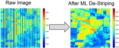
FINCH’s use of machine learning enables the team to reconstruct images with randomness and noise (left), transforming them into cleaner final images that can be more easily interpreted (right)
FINCH’s versatile spectrometer design also enables a wide range of other applications that extend beyond agriculture. Shofman shares that UTAT Space Systems is currently researching other meaningful scientific applications feasible with the payload’s target specifications, such as deforestation and vegetation tracking, flood mapping, oil spill detection, and coastal water quality assessment.
To unlock these applications, the Space Systems division must first overcome a few key challenges.
Hurdles in Designing, Developing, and Deploying FINCH
While FINCH may only be around the size of a loaf of bread, its small stature hides great complexity.
First, “there's a lot of electronics, a lot of thermal mechanical structures, and, in our particular case, there's also optical design,” says Shofman. “Then there's firmware to write the software that powers the satellite and the ground station to communicate with the satellite.”
On top of the technical challenges, there are also financial constraints. “The aerospace industry, and especially the space industry, is notorious for being very expensive,” says Shofman. Innovators must go about “accomplishing more for less without compromising on the scientific objectives, which is at the heart of our mission here at UTAT Space Systems,” he says.
To help reduce these costs, modern satellite developers can design standardized small satellites that can ride-share into space together with large satellites, forming a celestial “carpool.” This has resulted in decreased launch costs, which have empowered more organizations, such as UTAT Space Systems, to access space.
Still, there are challenges. With smaller designs, such as the ones the Space Systems division deploys, researchers need to spend more time determining what is possible while maintaining such a reduced size.
To overcome these hurdles, the team turned to simulation software.
Saving Costs and Advancing Agricultural Science With Simulation Software
Simulation is not a one-and-done tool for the UTAT Space Systems team. Instead, they rely on this solution throughout their process. “Designing the satellite requires extensive simulation work,” says Shofman. And this fact holds true across the many design-focused divisions at UTAT.
The team uses:
- Ansys HFSS high-frequency electromagnetic simulation software to design their own patch antenna for use on their satellite
- Ansys Systems Tool Kit (STK) digital mission engineering software to plan the mission orbit, perform orbital analyses, analyze the link budget, and perform Earth observation imaging simulations
- Ansys Thermal Desktop thermal-centric modeling software for studying thermal gradients across the satellite when it’s in orbit, which is critical for their sensitive optical payload
- Ansys Mechanical structural finite element analysis software for validating the satellite chassis and optomechanical housing against vibration thermo-elastic deformations. This includes analyzing the quasi-static, random vibration, and natural frequency analysis of the optomechanical housing and the entire satellite chassis
- Ansys Zemax OpticStudio optical system design and analysis software for developing and analyzing the optical design of their payload. This includes designing custom optical lens systems, optimization and tolerancing, and stray light analysis.
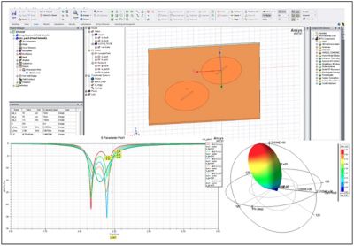
Ansys HFSS software was used to design circularly polarized 2 to 2.2-GHz patch antennas to receive and transmit satellite data. These images show the layout editor view of the patch antenna (top), the s-parameter plot (bottom left), and the false-color gain 3D plot (bottom right). Credit: Swarnava Ghosh, RF Lead
As a specific example of the benefits of simulation software, take the process of developing optimized brackets as part of FINCH’s optomechanical design. Here, the team needed to analyze the trade-off of mass and strength, Narkevich says. With Mechanical software, the team could identify and fix an area in their bracket design with a high stress concentration that was causing failure.
“By tweaking one design aspect that we didn't think about originally when we were just doing computer-aided design (CAD), we were able to validate our entire design in the launch conditions,” says Narkevich.
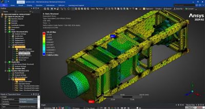
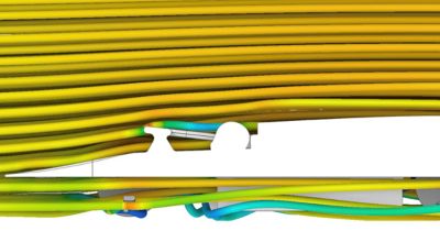
Stress results of a quasi-static analysis conducted on FINCH to analyze, verify, and optimize the CubeSat’s structures in Ansys Mechanical software. The outline tree (left) shows a random vibration simulation utilizing the results of a prestressed static structural analysis. The color-coded results (right) are overlaid on the model. Credit: Mario Ghio Neto, Opto-Mechanical Lead
Another example occurred when the team constructed an experimental prototype of their custom optical system, only to find the images blurry with aberrations. To address this challenge, the team turned to OpticStudio software. “It's virtually impossible to do this design on pen and paper,” says Shofman. “There's simply no pen-and-paper alternative that's as capable, and, frankly, no other software alternative that is as capable as OpticStudio software for lens system design.”
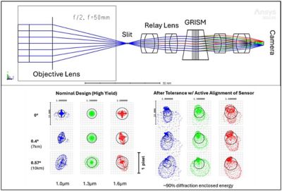
A ray-tracing diagram of the FINCH EYE optical payload (top), and the spot size diagram (bottom) after optimization (bottom left) and tolerancing (bottom right). Credit: Iliya Shofman, Optics Lead
“Simulations are instrumental in developing a design that we are confident will work in the challenging outer space environment,” says Shofman. “Rapid evaluations made possible with Ansys simulation software allow the divisions to quickly iterate and improve on designs. We can ensure that our design performs well using simulation before we commit to building it, which saves our team significant time and money.”
At the end of the day, “UTAT Space Systems has significantly benefited from access to Ansys software,” says Shofman. “Without Ansys software, it would be simply infeasible to proceed with most of our design work.”
Soaring Into the Future With FINCH and Beyond
The Space Systems division has high hopes for FINCH, which they envision will close a critical “sensing gap” for climate change science and environmental monitoring via its crop residue mapping data.
Narkevich says that looking ahead, the team also intends to widen its scope and pursue other sustainability-related goals. Such progress will be aided by UTAT Space Systems’ ambitious goal of continuously building and launching a satellite within a single undergraduate cycle.
Throughout it all, educational goals will remain paramount. UTAT Space Systems aims to continue sharing its knowledge and learning opportunities through outreach events targeting undergraduate and high school students and by upskilling its own members.
Using the skills they developed at the Space Systems division, alumni have gone on to amazing career opportunities, including founding startups that contribute to the aerospace industry worldwide and careers at leading governmental organizations and commercial companies such as MDA Space, Intel, General Motors, and Rocket Labs.
Shofman and Narkevich have found both their experiences at UTAT Space Systems and with Ansys simulation helpful for their future careers. Narkevich says, “I use the work that I do here at UTAT Space Systems in interviews all the time, and it always gives me the edge to say I have done these simulations.”
“Using [simulation] software as part of our learning helps guide us toward these career choices because we have so much more clarity about them,” says Shofman.
For other students interested in UTAT Space Systems and the benefits of simulation in their career, Shofman and Narkevich share the following advice:
- Narkevich: “Don't worry about your background … no matter your knowledge, background, experience, or lack thereof, you can contribute to the project no matter what.”
- Shofman: “The best software tends to be difficult, and one has to take time to learn the logic behind all the buttons and organization. But once you learn it, you’ll become much more versatile with it.”
Ansys is proud to support UTAT Space Systems in its goals by collaborating and partnering with the team. “Having access to free student software and a library of well-curated tutorials helps us learn the basics and start intelligent design faster,” says Shofman. “We take great pride in our contributions to academic literature, backed by the confidence Ansys software provides us.”
Learn more about the benefits of an Ansys Student Team Partnership.
Just for you. We have some additional resources you may enjoy.
“It's virtually impossible to do this design on pen and paper. There's simply no pen-and-paper alternative that's as capable, and, frankly, no other software alternative that is as capable as OpticStudio software for lens system design.”
— Iliya Shofman, optics lead for the Space Systems division
The Advantage Blog
The Ansys Advantage blog, featuring contributions from Ansys and other technology experts, keeps you updated on how Ansys simulation is powering innovation that drives human advancement.