Quick Specs
With Ansys DME Component Libraries, developers can directly benefit from decades of mission and system simulation expertise across many foundational capability areas.
Synopsys and Ansys power the future of innovation—connecting silicon to systems.
Ansys donne les moyens à la prochaine génération d'ingénieurs
Les étudiants ont accès gratuitement à un logiciel de simulation de classe mondiale.
Concevez votre avenir
Connectez-vous à Ansys pour découvrir comment la simulation peut alimenter votre prochaine percée.
Les étudiants ont accès gratuitement à un logiciel de simulation de classe mondiale.
Connectez-vous à Ansys pour découvrir comment la simulation peut alimenter votre prochaine percée.
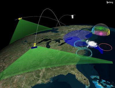
Ansys DME Component Libraries are a collection of development libraries well-suited for creating custom applications that benefit from web-first architectures.
Ansys DME Component Libraries are a collection of development libraries well-suited for creating custom desktop applications and web-first architectures. Available in Java and .NET, DME Component Libraries provide foundational mission and systems modeling capabilities in an architecture designed to scale efficiently.
With Ansys DME Component Libraries, developers can directly benefit from decades of mission and system simulation expertise across many foundational capability areas.
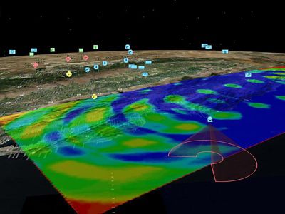
Ansys DME Component Libraries offer numerous building blocks, which includes some of the following major capabilities:
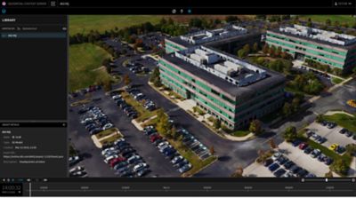
As part of Ansys DME Component Libraries, the Geospatial Content Server provides a comprehensive enterprise solution for hosting, processing, serving, and analyzing terrain, imagery, and other heterogeneous 3D data. In addition to a curated set of terrain, imagery, and 3D models, this geospatial content management system allows the external introduction of various common data types. The data is processed and available within your application for streaming visualization and analytical capabilities such as terrain analysis. Solutions built with Ansys DME Component Libraries can use this geospatial data solution.
DME Component Libraries Capabilities
This collection of software development libraries provides developers and systems integrators with fundamental mission and systems modeling capabilities that have been purpose-built to address scalability and performance in support of large enterprise deployments, OEM efforts, and other software solution design architectures requiring scalability and performance.
Extend your custom software application development to include the following individual libraries capabilities

Further explore the capabilities of Ansys DME Component Libraries by taking a look at the documented help files and getting started resources.
Find some helpful example applications and code samples on the following GitHub repo.
To learn more about product features and capabilities, download the brochure.