Synopsys and Ansys power the future of innovation—connecting silicon to systems.
ANSYS BLOG
April 27, 2023
Simulation Helps Keep NASA Satellites in Orbit
Ansys software supports flight dynamics that help reduce the probability of space collisions
Right now, there are thousands of satellites orbiting Earth, and several orbiting the Moon. We need them for weather monitoring, GPS navigation, the internet, and for space-based surveillance critical to national security, among other things. Like too many cars on a congested freeway, satellites are crowding into the same space — but they’re traveling at thousands of miles per hour.
To make matters worse, all this activity is happening with few if any formal standards or controls in place. As the number of satellites in orbit continues to grow, any collision event only compounds matters by creating debris for other spacecraft to avoid.
Number of pieces of debris in low Earth orbit (LEO) arranged by size. This data is based on an algorithm, not observational data.
To address these risks, efforts are underway to publish standards and behavioral norms to follow when sending a satellite into orbit. For instance, NASA has published the “NASA Spacecraft Conjunction Assessment and Collision Avoidance Best Practices Handbook.” Similarly, the United States Space Command (USSPACECOM) published a "Spaceflight Safety Handbook for Operators" that details processes for on-orbit conjunction assessment and collision avoidance. In addition, the Federal Aviation Administration (FAA) and the Federal Communications Commission (FCC) review operators’ collision avoidance plans before granting launch and operating licenses.
Spacecraft operators are also promoting safe operations protocols — and in fact, Ansys is one of many companies that endorsed the Space Safety Coalition’s “Best Practices for the Sustainability of Space Operations.” The aim of this publication is to create industry standards and improve collaboration around the world to mitigate the growing space debris problem. Still, many satellite operators have questions about how to respond to these recommendations.
“The tricky part is how do you implement these safe and sustainable best practices,” says John Carrico, owner and CTO of Space Exploration Engineering (SEE), which has designed, planned, and operated a number of satellite missions. “We know that each satellite operator has the goal of making sure their spacecraft can accomplish its mission. The fortunate thing is that when the satellite operations team performs their job in a non-negligent way, it not only keeps their mission safe, but it also prevents harm and interference with other spacecraft. While it’s easy to say we want to perform operations in a sustainable way, it actually requires carefully planned activities that rely on precise calculations, and Ansys software has been specifically designed to enable this.”
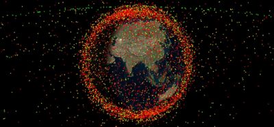
An Ansys Systems Tool Kit (STK) simulation of the thousands of satellites and debris pieces floating in orbit around Earth
Simulation Yields Safer Passing Distances for NASA Satellites
In February 2014, Carrico, as part of the flight dynamics team for the NASA Lunar Atmosphere and Dust Environment Explorer (LADEE) satellite, was at NASA’s Ames Research Center doing orbit determination and planning maneuvers. An important element of Carrico’s job was using Ansys Systems Tool Kit (STK) and Ansys Orbit Determination Tool Kit (ODTK) to analyze the trajectories of satellites in space, then planning a collision avoidance maneuver (CAM) to prevent them from making unwanted contact with other satellites or space debris.
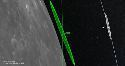
STK image of the orbit geometry of the NASA LADEE, provided by ODTK, and LRO spacecraft near their closest approach on February 27, 2014.
Originally there was an orbit maintenance maneuver scheduled for LADEE later that month. After the team shared the satellite’s anticipated trajectory based on an exchange of predicted ephemeris files (tables of astronomical positions of spacecraft trajectories at a particular time), it appeared that LADEE and another spacecraft — the Lunar Reconnaissance Orbiter (LRO) — were going to come too close for comfort. The inherent uncertainty in the predicted orbits made the probability of collision too risky to ignore.
At the time, both satellites were orbiting the Moon. The job of the LRO1 was to map the Moon’s surface, enabling discoveries about the origin and evolution of Earth and the solar system, while LADEE2 gathered information about the structure and composition of the lunar atmosphere. It was important scientific work. A collision would have brought these efforts to a permanent halt, costing NASA two satellites worth hundreds of millions of dollars and adding more debris for other satellites to avoid. Relying on the predictions from STK and ODTK, the LADEE and LRO teams came together and decided to postpone an originally scheduled station-keeping maneuver, thereby enabling the spacecraft to pass each other at a safe distance.
Scenarios like this aren’t “one-and-done” situations by any means. Commercial and federal spacecraft operators maintain dedicated teams that receive continual updates on the position of satellites relative to each other and any detectible space debris as they orbit Earth or the Moon, to avoid the possibility of collision. Every satellite will most likely encounter other satellites or debris multiple times over the course of its travels. Sometimes the best course of action is no action, while other times, mitigation requires a maneuver. These maneuvers must be planned well in advance — anywhere from a few hours to a week — based on predictions using simulation.
Plotting a Different Course
When satellites from different agencies are involved, simulation can help fill in the gaps left by a lack of international standards. For example, the Indian Space Research Organization (ISRO), like NASA, has launched a series of spacecraft, including the Chandrayaan-2. The Chandrayaan-2 consisted of a lunar orbiter and a lunar rover, and its objective was to study lunar surface composition and the abundance of water on the Moon. It just so happened that NASA’s LRO shared a similar mission.
In October 2021, both spacecraft were scheduled to come very close to each other as they were both studying the Moon from a polar orbit. Using STK, the team determined that the spacecraft would be less than 100 meters apart. With support from Ansys software and a mutual agreement with NASA, ISRO executed a CAM based on this information, and it added calculations based on a new orbit that would help both satellites avoid close passes like this in the future.
“In the case of the Chandrayaan-2 orbiter and the LRO, most of the international data available could not necessarily capture the information needed to plot these maneuvers successfully,” says Ravnish Luthra, CEO of ITGlobe, an Ansys partner supporting ISRO. “Simulation provided the truest picture of what was happening around the Chandrayaan-2, enabling ISRO to execute a precise CAM and plot a different course for the future.”
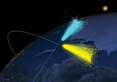
Iridium 33-Cosmos 2251 satellite collision debris field reconstructed from measured data using Ansys Systems Tool Kit (STK).
While the travels of the LRO may not be governed by a definitive set of codified rules, they are supported by a dedicated team of scientists, engineers, and other experts using simulation to make predictions about the trajectory of satellites in space. For them, Ansys simulation delivers real-time, accurate data with near-perfect precision that leads to more positive outcomes.
Making a Positive Impact on Satellite Collision Avoidance
With so many governments and commercial organizations relying on satellites, we need to contend with the challenges of congestion that could eventually impede our efforts to look beyond Earth’s atmosphere. The result of satellite collisions — the tremendous amount of debris they leave behind — has the potential to create even greater congestion, which could lead to even more collisions.
“During a collision, the hypervelocity impact and shock waves can rip an entire structure apart,” says Adam Gorski, Enterprise Account Manager, Aerospace and Defense Sales at Ansys. “One satellite mission could create dozens of orbital objects including satellites, payload fairings, and spent rocket stages. Then there have been collisions where one satellite became thousands of pieces of trackable, potentially catastrophic debris.”
While there may not be any universally accepted rules in space now, commercial and federal space operators are working toward establishing clear standards and governance for the space domain. Through collaborative data and models, simulation is helping to build an essential bridge to make space safer for now. And, once those rules are in place, simulation will be essential to complying with them.
Does your latest mission involve sending satellites into orbit? Find out what Ansys Systems Tool Kit (STK) and Ansys Orbital Determination Tool Kit (ODTK) can do to gain situational awareness of the deep space environment and protect your assets.