-
-
Software gratuito per studenti
Ansys potenzia la nuova generazione di ingegneri
Gli studenti hanno accesso gratuito a software di simulazione di livello mondiale.
-
Connettiti subito con Ansys!
Progetta il tuo futuro
Connettiti a Ansys per scoprire come la simulazione può potenziare la tua prossima innovazione.
Paesi e regioni
Customer Center
Supporto
Partner Community
Contatta l'ufficio vendite
Per Stati Uniti e Canada
Accedi
Prove Gratuite
Prodotti & Servizi
Scopri
Chi Siamo
Back
Prodotti & Servizi
Back
Scopri
Ansys potenzia la nuova generazione di ingegneri
Gli studenti hanno accesso gratuito a software di simulazione di livello mondiale.
Back
Chi Siamo
Progetta il tuo futuro
Connettiti a Ansys per scoprire come la simulazione può potenziare la tua prossima innovazione.
Customer Center
Supporto
Partner Community
Contatta l'ufficio vendite
Per Stati Uniti e Canada
Accedi
Prove Gratuite
ANSYS BLOG
December 19, 2023
Ansys and Cesium Enhance Mission Modeling with 3D Geospatial Data
From cameras and lidar on satellites, aircraft, and cars to artificial intelligence (AI)-generated semantics and open data policies, 3D geospatial data is more easily available, at a higher resolution, and more frequently refreshed than ever before. Now this data needs to be made accessible, shareable, and ultimately usable — which is where Ansys technology partner Cesium comes in.
"The sheer volume of real-world 3D data being collected is creating opportunities in almost every field," says Cesium CEO Patrick Cozzi, creator of Cesium and a recognized expert in 3D graphics and geospatial technologies.
Cesium builds technology that unlocks the potential of real-world 3D data. Their vision is a world in which developers easily build 3D data into their apps, data providers share massive models and datasets in seconds with just a link, and insights gleaned from 3D data are used across industries and wherever they provide value.
Cesium began as an internal project at Ansys Government Initiatives (AGI) — the United States national security division of Ansys — in 2011, when a team of computer graphics developers set out to fill the vital need of temporal geospatial visualizations on the web. They built what became CesiumJS, an open-source 3D visualization engine.
Cesium has since evolved into a complete platform for 3D geospatial data. At the heart of this platform are its 3D tiling pipelines, which transform massive and diverse 3D geospatial data into streamable 3D content that can be used on any device, online or offline. Cesium is also the creator of 3D Tiles, an open standard for 3D geospatial content adopted as a community standard by the Open Geospatial Consortium.
Visualizing Complex Multidomain Scenarios
To visualize multidomain scenarios — from urban environments to deep space — Ansys integrates Cesium with Ansys Systems Tool Kit (STK), Ansys Digital Mission Engineering (DME) Component Libraries, and Ansys RF Channel Modeler.
AGI has served the United States’ and its allies’ aerospace and defense industries for decades, modeling multidomain systems of systems in time-dynamic environments. These simulations enable engineers to build and test virtually rather than experimenting on multiple physical prototypes, decreasing manufacturing costs and risk.
“Cesium has truly revolutionized the geospatial ecosystem, and driving for modern open standards is phenomenal,” says Shashank Narayan, senior director of research and development (R&D) at AGI.
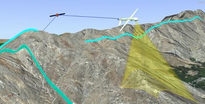
Leveraging high resolution terrain data for sensor coverage and data collection opportunities
STK Integrates Cesium Pipelines
Released in 1989, STK is a physics-based mission modeling environment that incorporates visualization of land, sea, air, and space scenarios and the airplanes, spacecraft, and other vehicles and facilities that go with them. Users can model the relationships among the moving objects and apply constraints — such as clouds, terrain, and buildings — to assess their impact. For example, how might clouds affect imagery collection or navigation? How might flying in a canyon affect radio or internet access?
For context and constraints, engineers can use STK Enterprise, which includes the Geospatial Content Server (GCS) capability and integrates the CesiumJS globe and Cesium ion’s tiling pipelines. If STK users have accounts, they can seamlessly access Cesium World Terrain and Bing Maps Aerial imagery and include their own datasets, which can be tiled into 3D Tiles for optimal streaming and visualization.
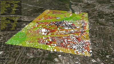
Communications signal strength across an urban environment for low altitude commercial unmanned aircraft systems (UAS) operations
DME Component Libraries and Cesium
Ansys DME Component Libraries are a collection of class libraries in .net and Java, such as dynamic geometry, route design, orbit propagation, and GCS. Engineers can use DME Component Libraries to build custom applications that incorporate analytical capabilities found in STK. DME Component Libraries increase precision and interoperability with the Cesium ion software development kit (SDK), which extends the open-source CesiumJS JavaScript library with additional 3D analysis tools and user interface (UI) widgets.
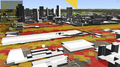
Commercial drone
RF Channel Modeler and Cesium
RF Channel Modeler — set to be released in early 2024 — is uniquely positioned to address the needs of radio frequency (RF) systems designers, telecommunications planners, and network engineers. It enables users to predict signal coverage, evaluate waveform performance in bespoke locations, mitigate interference, and achieve the right balance between coverage and capacity. High-fidelity modeling and simulation enable these users to better understand the growing complexities and sophistication of today’s communications systems while optimizing their proposed designs.
RF Channel Modeler builds on top of STK and connects its dynamic mission modeling capabilities with high-fidelity datasets and ray tracing technologies to analyze system performance at individual channel levels. This solution relies on 3D Tiles to introduce the necessary high-resolution urban environment models, which can be streamed directly with Cesium ion for accurate city features and metadata. RF Channel Modeler’s workflow lets users add base stations, cars, airplanes, or other objects that may be needed to accurately analyze and assess the performance of modeled RF systems in its simulated environment.
With Cesium’s accurate, time-dynamic 3D globe and curated geospatial data, Ansys customers see their mission scenarios and perform analyses in real-world contexts.
Contact Ansys to learn more about their digital mission engineering solutions, or connect with Cesium to learn more about their offerings.