-
-
Accédez au logiciel étudiant gratuit
Ansys donne les moyens à la prochaine génération d'ingénieurs
Les étudiants ont accès gratuitement à un logiciel de simulation de classe mondiale.
-
Connectez-vous avec Ansys maintenant !
Concevez votre avenir
Connectez-vous à Ansys pour découvrir comment la simulation peut alimenter votre prochaine percée.
Pays et régions
Espace client
Support
Communautés partenaires
Contacter le service commercial
Pour les États-Unis et le Canada
S'inscrire
Essais gratuits
Produits & Services
Apprendre
À propos d'Ansys
Back
Produits & Services
Back
Apprendre
Ansys donne les moyens à la prochaine génération d'ingénieurs
Les étudiants ont accès gratuitement à un logiciel de simulation de classe mondiale.
Back
À propos d'Ansys
Concevez votre avenir
Connectez-vous à Ansys pour découvrir comment la simulation peut alimenter votre prochaine percée.
Espace client
Support
Communautés partenaires
Contacter le service commercial
Pour les États-Unis et le Canada
S'inscrire
Essais gratuits
ANSYS BLOG
August 10, 2022
Bird’s-Eye View: Using Simulation to Understand Changing Wind Behaviors
Located 1,340 miles south of Cape Town, Marion Island is a South African territory renowned for its natural beauty. This subantarctic island is home to a research base, a meteorological station, and over 2 million seabirds that represent at least 28 known, unique species, with many classified as endangered. It was designated a Special Nature Reserve by the South African government in 1995, and access is strictly limited to scientists and researchers.
With a latitude of 46° 54’ 45”, Marion Island sits in the region of the southern hemisphere called the “Roaring Forties” because of its constant and often high-velocity winds. As the effects of climate change increase, these harsh, windy conditions are beginning to affect not only the island’s wildlife but also its vegetation. Soil erosion and higher levels of salt spray are destroying nesting habitats, as well as killing grasses, mosses, and other plants.
The South African National Antarctic Programme (SANAP) was looking for a way to understand and mitigate the impacts of climate change on Marion Island, particularly regarding wind damage. While SANAP’s scientists had access to general meteorological information about wind, such as its direction and speed, they needed to understand exactly what was happening at ground level across the island’s rugged terrain.
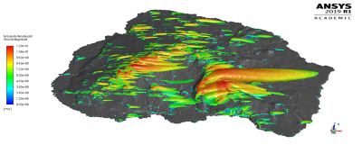
Simulated turbulent wind intensity plot across Marion Island.
In 2017, SANAP researchers called on Professor Ken Craig at the University of Pretoria for help. As a senior member of the Clean Energy Research Group in the Department of Mechanical and Aeronautical Engineering, Craig heads the CFD research in this group.
Since 1999, Craig had been applying Ansys Fluent to develop models of solar receivers and generators; metallurgy and manufacturing processes; and other CFD-based problems in his research. He also uses Fluent in his undergraduate and graduate courses on fluid dynamics, CFD, and simulation-based design. But could Fluent accurately model an entire 115-square-mile island, characterized by cliffs, mountains, valleys, and wetlands?
“I strongly believe that Fluent provides a very accurate solution for CFD modeling — and that when you have as good a piece of software, you should stick with it,” says Craig. “But I don’t think Fluent has ever been applied on such a large scale to an isolated land mass. Not only was the scale intimidating, but so was the sheer amount of friction, turbulence, velocity, and other physics-based problems Fluent would need to solve.”
Always up for a challenge, Craig agreed to join forces with an existing SANAP program to gain a better understanding of changing wind behaviors on Marion Island. He enlisted master’s student Kyle Goddard to lead the island-wide wind modeling effort, which would become the basis for Goddard’s thesis, as well as of a recent paper published in the scientific journal Ecological Modelling.
Modeling Airflows and Terrain: A Complex Problem
The University of Pretoria team set up Fluent simulations that reflected 16 different wind flows approaching Marion Island from different directions. To map the island’s terrain, team members relied on digital elevation models from airborne drone studies.
Craig and Goddard experimented with different approaches for generating a mesh that was finely detailed enough to reflect the island’s terrain, but still large enough to encompass the entire landmass. They settled on a mesh with polyhedral cells and devised a novel strategy for reusing a single mesh system to simulate multiple climatic conditions and wind directions around Marion Island. This strategy basically entailed using a common region to all the models, and extending the upstream and downstream sea regions in the respective wind direction.
While the final generated mesh was very large, ranging between 87 and 214 million cells, the team was able to solve it by relying on the national South African high-performance computing (HPC) cluster, which distributed complex physics problems such as turbulence across hundreds of cores. Postprocessing made the final wind models more manageable and user-friendly.
All of the wind direction simulations were then combined into a single wind velocity map, generated by weighting each of the simulations by the frequency of wind prevalence measured in the corresponding wind sector. This island-wide map, believed to be the first of its kind, will have many applications in future scientific studies of Marion Island.
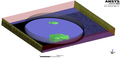
Mesh around Marion Island and Prince Edward Island.
In conjunction with the computational simulations, the team installed 17 wind data logging stations at key locations on the island. Raw outputs from these stations were cleaned and converted into an easily accessible database — the Wind on Marion Island (WMI) dataset — that now reflects all physical wind measurements gathered since 2018.
To validate the accuracy of its wind models, the team compared its simulation results against actual collected wind data from the WMI database. Team members focused on three directions that account for over 74% of the island’s wind patterns: north westerly, westerly, and south westerly. The Fluent simulation results predicted the wind direction to within 5% and velocity and turbulence levels within 30%. It should be mentioned that the wind measurements were constrained because of environmental regulations and anchoring limitations that only allowed for measurements up to a one meter height.
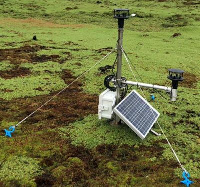
One of 17 wind data logging stations on Marion Island.
“When supporting scientific research in the field, it’s critical to have an accurate tool that replicates real-world conditions in high fidelity,” notes Craig, “and Fluent provided us with that tool. It’s extremely powerful — and one of only a few solutions I can think of to create this kind of morphology at such a large physical scale.
“We were very pleased with the relative ease of setting up the mesh in Fluent once we became proficient and with the accuracy of the results. I wouldn’t know how to solve such a large, complex problem using any other tool.”
One Reliable Model with Diverse Applications
Thanks to the efforts of Craig and his student researchers at the University of Pretoria, SANAP and other environmental protection groups have a reliable means of estimating wind properties near ground level on Marion Island. Average wind speeds, turbulence, gusting, and other fine-scale wind behaviors can be recreated at any location on the island without using environmentally intrusive physical surveillance methods.
Climate change scientists can use the model to assess how wind patterns are evolving over time and how those changes will impact the island’s bird and plant species. Already, the Fluent wind model is being applied to predict plant seed dispersal, investigate bird flight and nesting behaviors, and study the wind’s impact on mortality rates for both animal and plant species.
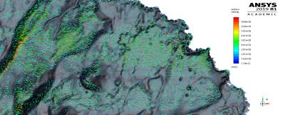
Wind velocity vectors across the island simulated by Ansys Fluent.
In 2024, conservationists plan to eradicate house mice from Marion Island, as these rodents are killing the chicks of endangered species such as the wandering albatross. Introduced by seal hunters in the early 19th century, today these rodents are overrunning the island. An effort called Mouse-Free Marion plans to use helicopters to strategically spread rodenticide across the island. The wind models produced by Craig and his team will help in creating flight maps, assessing landing and takeoff conditions, and predicting the most effective means of dispersing bait during the campaign.
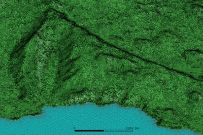
Meshing Marion Island.
“The Marion Island wind modeling project is a great example of the value delivered by simulation,” Craig says. “Given the extreme weather conditions and the pristine state of Marion Island, it would be impossible to create physical stations to measure and study changing wind patterns. Everyone invested in protecting this island is grateful that Fluent was able to produce such a compelling approximation of the real atmospheric phenomena occurring on Marion Island without the need for permanent wind measurement systems or other environmental impacts.”