


トピックの詳細
Lidarとは
Lidarは「Light Detection and Ranging」の略で、光パルスを使用して環境をマッピングするリモートセンシング技術です。Lidarは、ホームセキュリティシステム、バーコードスキャナ、顔認識システムにも使われていますが、完全自動運転の推進に大きく貢献していることでよく知られています。Lidarは、レーダーやソナーとは異なり、高解像度の3Dデータを提供するため、自動車、地質学、農業などのさまざまな業界で重要なツールとなっています。
Lidar、レーダー、ソナーの違い
20世紀初頭、距離の測定には電磁波を使用するレーダー(Radar: Radio Detection and Ranging)と音波(アクティブソナー音)を使用するソナー(Sonar: Sound Navigation and Ranging)が用いられていました。その後、1960年代にレーザーが発明されたことで、フォトニクスの力を活用した新しい距離検知システムが開発されました。Lidarは、光の速度で私たちの世界を測定、マッピング、解釈することを可能にします。
距離検知システムの比較
| レーダー | ソナー | Lidar |
センシング方法 | 電磁波 | 音波 | 電磁光波 |
一般的な適用分野 | 航空管制、天気予報 | 海洋航行、水中マッピング、考古学 | 自動運転車、地上マッピング、ロボティクス |
メリット |
|
|
|
デメリット |
|
|
|
Lidarの仕組み
どのLidarシステムも、光波を発射するエミッター、反射した光波を捕捉するレシーバ、データを解釈するプロセッサの3つの主要な部分で構成されています。一瞬で、何千ものパルス状の光波が物体に衝突し、反射して戻り、正確なタイミングデータが提供されることで、環境内に存在する物体とその動きを厳密に把握できるようになります。
レーザー放射
エミッターは、短いパルスのレーザー光を毎秒186,000マイルの速度で空気中に発射します。
光検出
レーザーパルスが物体に衝突すると、光のごく一部が反射してレシーバに戻ります。
データ処理
プロセッサでは、光の移動時間が測定され、物体までの距離が計算されて、データが詳細な3Dマップやモデルに変換されます。
複数のレーザーエミッターと高速(毎秒数十万回)のパルス光を使用することで、Lidarシステムは広い視野にわたって、さまざまな角度から測定値を捕捉できます。その結果、位置、距離、動きに関する正確な情報を提供する3Dマップが作成されます。
Lidarの用途
空気中にレーザーを発射するというアイデアは非常にSF的に思えるかもしれませんが、Lidarは現在、次のようなさまざまな業界や用途で使用されている一般的な技術です。
自動運転
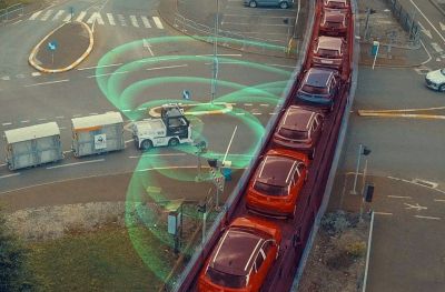
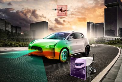
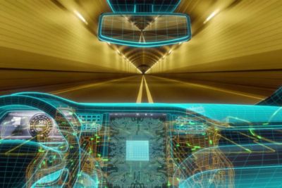
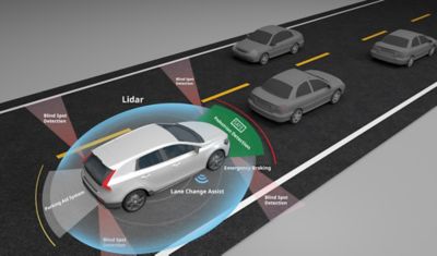
Lidarは、カメラやレーダーセンサーと連携して、自動運転車の安全なナビゲーションに不可欠なデータを提供します。Lidarは、車両周囲の3Dマップを作成することで、物体の形状、大きさ、位置に関する正確な情報を収集し、道路標識、他の車両、障害物、歩行者を検出します。また、長距離でも高い精度を達成することで、自動運転車での車線の追跡や衝突防止も可能にします。
コンピュータビジョン
コンピュータで画像やビデオから意味を引き出すには、カメラだけでは得られない詳細情報が必要です。Lidarから提供されるデータにより、深度情報と画像を融合させることで、目に見える世界を認識して解釈できるようになります。Lidar支援のコンピュータビジョンは、拡張現実(AR)、ジェスチャー認識(ゲーム)、医療モニタリングで採用されています。
顔認識
認証のために顔認識を必要とするシステムでは、Lidarを導入することで精度が高まり、成り済ましが減ります。Lidarの非常に詳細な点群には、顔の構造の輪郭と寸法に関する正確なデータが含まれているため、システム側で人の顔と2D画像を区別できるようになります。Lidarは独自の光源を使用しているため、照明の暗い場所や暗闇でも顔をマッピングできます。
ロボティクス
自動運転車と同様に、ロボットは周囲を安全にナビゲートするためにLidarを使用しています。Lidarの詳細な3Dマップにより、ロボットが倉庫や工場などの忙しい環境や変化する環境で通るルートに関する情報に基づいて瞬時の意思決定を行うために必要な正確なデータが提供されます。また、製造、農業、捜索救助などの複雑な状況で作業するロボットの物体認識と操作機能を強化するのにも役立ちます。
Lidarについて初めて耳にしたのが自動運転に関する話題という方も多いでしょう。この場合、自動運転のレベル5(あらゆるシナリオで人とほぼ同じパフォーマンスを達成)が最終的な目標です。それを達成するには、カメラ、レーダー、超音波、Lidarなどの一連のセンサータイプの連携が必要です。ただし、衝突や障害物を回避できるようになるには、Lidarの優れた精度と範囲(たとえば、200メートル以上離れた物体をはっきりと視認できる)が不可欠です。
Lidarの種類
自動運転の中でのみ使用できるタイプとして、スキャニングLidar、回転型Lidar、フラッシュLidarなどがあります。さらに、現在のLidarシステムの大半はToF(Time of Flight)検出技術を使用していますが、多くの次世代システムでは周波数変調連続波(FMCW: Frequency-Modulated Continuous Wave)検出の活用が検討されています。
メーカーは、1つのタイプを使用することも、それらすべてを一度に使用することもあります。自動車以外の分野では、Lidarタイプの選択肢は増え続けており、範囲、モビリティ、環境に関する特定のニーズに対応したさまざまなオプションが提供されています。
以下に、Lidarシステムを表すために使用される一般的な用語の定義を示します。
- 回転型Lidar: 光源を回転させて、シーン全体から画像をキャプチャします。回転は、機械的(自動運転車の一番高い位置に搭載された装置)に駆動されます。
- スキャニングLidar: 機械的な回転ではなく、高度なテクノロジー(フェーズドアレイ、回折光学素子、メタサーフェスなど)を使用して、シーン全体から画像をキャプチャします。多くの場合、「ソリッドステート型Lidar」とも呼ばれます。
- フラッシュLidar: 光源アレイを使用して、(カメラのフラッシュのように)1回の撮影でシーン全体の画像をキャプチャします。この技術は回転型Lidarよりもロバストですが、一般的には短い距離に適しています。
- ToF検出: このLidar検出方法は、ToF(光源が発射されてからレシーバで検出されるまでの時間)を使用して、検出された物体までの距離を計算します。
- FMCW検出: このLidar検出方法は、わずかに異なる周波数で複数のビームをシーンに発射し、それらのビーム間の干渉を測定して、物体までの距離を計算します。この検出方法は、同時に動作している(他の車両に搭載されている)他のLidarシステムからのデータの破損に関して、ToF検出よりもロバストですが、はるかに多くの計算処理が必要になります。
- 航空機搭載Lidar: 飛行機、ヘリコプター、ドローンなどの航空機に搭載され、動作するLidarシステムです。
- 地上車搭載Lidar: トラックなどの地上車に搭載され、動作するLidarシステムです。
Lidarの利点と課題
スピードと精度が最優先事項であるアプリケーションでは、Lidarが最適なテクノロジーです。ただし、Lidarがセンシング方法の中で最も高価なままであれば、一般的な普及への道のりは困難になるでしょう。
Lidarの利点 | Lidarの課題 |
比類のない精度 | コストが高い |
Lidarの未来
あらゆるテクノロジーでスピードと精度に対する要求が高まるにつれて、システム全体でのLidarの統合が増えていきます。ヘルスケア、輸送、農業など、世界を変える産業の未来は、Lidarで達成されるイノベーションによって形作られます。
Lidar機能が次のレベルに到達するために、エンジニアとメーカーはシミュレーションの予測洞察を活用します。設計者は、Ansys Speos、Lumerical、Zemax、AVxcelerateなどの光学およびフォトニクスソフトウェアを使用して、さまざまなシナリオを解析し、Lidarの性能を正確に予測できます。シミュレーション、テスト、妥当性確認を通じて、光を利用したアイデアをさらに迅速に前進させることができます。
注目すべきLidar関連のトレンド:
- スマートシティプランニング
- 無人航空機(UAV)
- 環境研究と環境保全
- ウェアラブルの統合
道を横断する歩行者を見つける場合や、市街地に出現した陥没穴を探す場合でも、Lidarは驚くほどの精度とスピードで周囲の物体を検知しています。さまざまなテクノロジーにLidarの力を結集することで、今後も多くの素晴らしい発展を期待できます。
関連リソース
Ansysができること
Ansysができること
Contact Us
お問い合わせ