


ANSYS BLOG
February 7, 2024
Digital Mission Engineering: What’s New 2024 R1
With the first release of 2024, Ansys digital mission engineering (DME) products continue to enable pervasive, mission-level simulation through model-based digital engineering methods. A collection of new features includes enhanced subsystem and sensor payload modeling, updated tools and workflows targeting large constellations of platforms, asset grouping capable of analyzing data relay routes and optimizing end-to-end connectivity solutions, and strengthened integration and automation capabilities through Python scripting and API enhancements.
Systems engineers will enjoy high-fidelity representations of their modeled systems and streamlined methods for both representing and analyzing performance against their mission-level requirements. With fidelity improvements to urban propagation methods for radio frequency (RF) systems and options for ingesting Google’s global, photorealistic 3D data for enhanced realism, users will notice incremental workflow and usability improvements that will help reduce model configuration steps.
In addition, capabilities between Ansys Systems Tool Kit (STK) and Ansys Orbit Determination Tool Kit (ODTK) continue to align and provide satellite and spacecraft owners and operators with enhanced flight dynamics modeling capabilities. With quicker methods for quantifying common sensor coverage metrics, installed Python examples for automated rendezvous and proximity operations, and new ODTK capabilities to process tracking measurement data for surface vehicle motion on planetary bodies, these tools provide capabilities targeted to today's space mission design and operation needs.
Ansys DME Component Libraries continue to provide multidomain mission modeling and simulations capabilities ideal for developers, systems integrators, and custom application builders. This latest release unlocks new features focusing on expanded geospatial analysis such as multithreaded coverage grid generation, which speeds up the ability to grid larger areas of interest. There are also denser coverage maps to explore system performance across geographic regions, as well as updates to the libraries available for embedded 3D visualization.
Improved Data Routing and Optimization for Large Satellite Constellation Designs
The challenge of multidomain system design includes considering the connectivity between asset groups such as satellite constellations, ground-based networks, and other systems that can be part of an end-to-end chain of custody for providing connectivity. STK now offers expanded capabilities for users leveraging STK’s Chains and Constellation objects to construct and analyze complex data relay and multi-object connectivity paths. Updates include the ability to introduce additional constraints such as minimum/maximum number of hops within the strands connecting source and target objects, and metrics to qualify optimal paths such as total distance, total time, communication metrics, and other calculations. All-domain connectivity is now easier than ever to assess with STK because the new enhancements remove some of the external analysis and let users define the complex routing situations more directly.
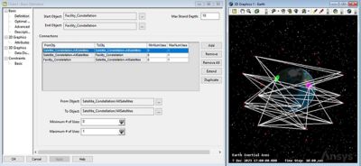
Define complex routing situations more directly to optimize and route communications paths across complex networks of objects.
Python Enhancements for STK
Leveraging STK’s object model APIs for custom application development, containerization, or general workflow automations, the Python enhancements in Ansys 2024 R1 support a new gRPC methodology for connecting to instances of STK Desktop and STK Runtime. This is an advancement in the way customers can automate and interact with their STK scenarios or custom STK Engine applications, and it offers a modern approach to packaging automated workflows via Python scripting. This also greatly simplifies remote API interactions to containerized STK applications and use cases. Enabling customers to leverage a more flexible API interaction with their STK-driven workflows, it provides a streamlined way to interact with containerized instances. This reduces complexity, simplifies setup efforts, and provides an alternative way to architect solutions for scalability and performance.
Streamlined Aircraft Performance Modeling with STK Premium Air
Creating a detailed performance model is essential to realizing the value of Ansys STK’s Aviator capability for defining realistic performance-based aircraft trajectories. It provides flexibility in defining models and an elevated level of detail to enable powerful analysis with a range of options available to users for defining aircraft performance models. Further, to accommodate Aviator’s broad trajectory modeling, these models interact in complex ways with modeled procedures used to detail aircraft flight paths.
All these capabilities combined may introduce an intimidating set of options, especially for users unfamiliar with aviation flight planning or aircraft flight performance. To help users get started quicker and with minimal modeling steps, enhanced workflows were streamlined to help guide users through defining aircraft performance models. The updates encourage exploration into Aviator’s advanced capabilities by helping customers understand the existing performance model capabilities while increasing confidence in building aircraft models. Users will benefit from simplified definition workflows directly within STK’s Aviator design tool, which shortens the runway to achieving high-fidelity model-based flight trajectories.
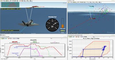
Get started quicker with minimal modeling steps and increase confidence in building aircraft models.
Coverage Tool
The Coverage wizard streamlines the setup of common or simple sensor coverage analysis. Placing all the necessary inputs required for a coverage computation into a single panel, it reduces the complexity of the graphical user interface and makes simplistic sensor coverage situations easier and quicker to analyze. Finding answers for basic sensor coverage questions can be done with the rapid modeling workflow, which enables users to understand their sensor coverage over large global regions or areas of interest.
Google 3D Tiles
3D Tiles is an open standard, designed to describe and organize massive geospatial datasets in a manner that is efficient for both 3D rendering and analytical querying. This standard is widely used across the geospatial community and is an OGC Community Standard. 3D tilesets adhere to this specification and can be used to represent massive point cloud data, dense meshes from photogrammetry captures, vast cities defined in CityGML/OpenStreetMap, high-fidelity computer-aided design (CAD) models, and more.
With this latest release, STK adds the ability to ingest and represent Google’s entire photorealistic 3D tiles dataset. This includes all of Google’s high-resolution, 3D meshed data, which covers more than 2,500 cities across 49 countries. STK users will enjoy the ability to stream all of this data into their STK scenarios and begin exploring their traditional multidomain missions with even more realism. This additional high-fidelity contextual layer helps users accurately depict the environment in which their systems are being designed to operate by representing 3D buildings, landmarks, and the natural surrounding for greater geographic context. Design stakeholders and decision-makers will appreciate this highly accurate representation of their modeled missions and conceptual operations within STK’s system of systems simulation environment.
Urban Propagation
STK offers communications and RF systems engineers the ability to model and simulate their communications systems and understand anticipated performance across different modeled circumstances and operational environments. By introducing urban geometries, engineers can evaluate their designs and understand the impact that urban terrain and building geometries may have on their ability to maintain communications links across terrestrial, airborne, and even space-based systems. While STK has offered the Urban Propagation (UProp) capabilities to its users for many years, this latest release includes some significant updates to the urban propagation capability, which leverages REMCOM’s Wireless Insight algorithms and is specifically tailored for use within STK.
Users will now enjoy improved accuracy and performance, thanks to the adoption of the latest 64-bit urban propagation engine. Better support for reflections along with refraction and diffraction is also included, which supports higher frequency applications. Users who need to consider their RF systems’ performance within urban environments can now leverage this faster, higher-fidelity model for urban propagation. New use cases with higher-frequency applications can now leverage this expanded urban propagation capability directly within Ansys STK Pro.
Behavior Execution Engine (BEE) — SysML Client STK Plugin
The installation of Ansys Behavior Execution Engine (BEE) now includes a "SysML Client" user interface that provides a convenient way to interact with your SysML modeling project and run simulations using the Delegate Modules that connect to your analysis and simulation tools. This new capability comes in two form factors. For STK users, there is now a UI plugin that provides the SysML Client inside the STK environment. For other users, or users who prefer interacting with SysML outside the STK application, BEE also includes an independent SysML Client application. The new SysML Client reintroduces new and improved diagnostic tools and code generation capabilities that were previously removed. These tools assist users during the model and delegate generation process, streamlining development efforts and accelerating the timeline to arrive at meaningful analytical results.
ODTK Surface Vehicle Motion Modeling
Advanced capabilities for interplanetary mission support continue to be a focus for STK and ODTK. This release includes expanded support for surface vehicle tracking and position solutions. Being able to provide tracking and position estimation for planetary rovers requires that mission plans be considered along with collected tracking data to resolve accurate route solutions. Users can now process their tracking data while referencing planned velocity vectors and long stationary periods without position uncertainty growing unnecessarily. Mission plans and anticipated actions can now be referenced and considered when processing measurement data, providing more accurate trajectory and position information.
In addition, ODTK’s optical navigation capabilities have been updated to include the simulation of optical landmark measurements. These landmarks’ locations are supplied to ODTK and associated with the appropriate planetary bodies, which can be important for missions in lunar and cislunar space to reduce dependence on Earth-based tracking.
DME Component Libraries
Updates to the DME Component Libraries for this release include some key enhancements. First, coverage grid point generation can now be multithreaded, which enables the generation of large numbers of grid points. Users can now take advantage of the calculation context threading policy to utilize all available threads to improve performance. Conversions between all ITRF frame versions are now also supported. Position accuracy improvements ranging from millimeters to meters can be realized when using data represented in different ITRF frames.
Test and Evaluation Tool Kit (TEKT)
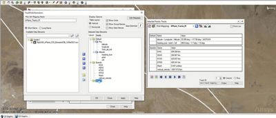
2024 R1 also brings several exciting improvements to Ansys Test and Evaluation Tool Kit (TETK). To start, the Tracks workflow panel has undergone a sizeable user interface (UI) change, adding in multiple tabs to better organize the various properties you can set. A new "Current State" tab and capability has also been added. Enabling Current State for a given track object allows you to highlight unique track points in your dataset with a custom marker and label at the current animation time in your scenario. This enables you to see the current state of tracks while simultaneously keeping the rest of your dataset static. It is especially useful for track data in which more than one track point is occurring at a time.
Track Pick Info mappings have also seen a sizeable improvement. Compared to the previous single list of data elements, Pick Info mappings now allow you to put your data into custom groups and nest multiple elements into a single row or column field. Additionally, there is now individual control for decimal precision, display name, and unit for each data element. These changes provide more flexibility in how you can display and explore your data.
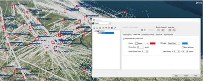
Put your data into custom groups and nest multiple elements.
Another change is that TETK graphs can now utilize unique line styles for each data element and can be configured to show lines, points, or both. This can be useful for better distinguishing data elements from one another, especially in busy graphs. Another addition to graphs is the ability to set a logarithmic scale for your axes.
Lastly, we have overhauled the TETK training tutorial. Most of the sample data files have been updated to increase realism, several sections have been rewritten, and a few new sections have been added to showcase newer capabilities from the last few releases. The new sections include graph overlays, graph annotations, scalable vector graphic displays, track pick updates, and multi-metric satisfaction intervals.
Learn more about STK, ODTK, DME Component Libraries, and 2024 R1.
See What Ansys Can Do For You
See What Ansys Can Do For You
Contact Us
Contact us today